

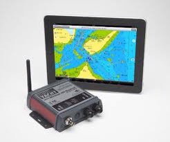
AIS and iPad
Our day-to-day method of navigation was done using the Dawn Treader’s Ramarine radar chart plotter in parallel with paper charts. The chartploter uses CMAP cards but is positioned below decks. In addition to this we have an iPad running an application called iNavx which uses Navionics electronic charts.
The AIS (Automatic Identification System) which lets us know the position speed and point of closest approach of other ships – uses a ‘Digital Yachts Wireless AIS receiver’. There is a link into the chartploter NMEA data bus, as well as a wireless link to talk to the iPad. This way we can have the iPad on deck, working as a very flexible chartplotter with AIS and waypoint data shown overlaid on screen, all within the iNavx application.
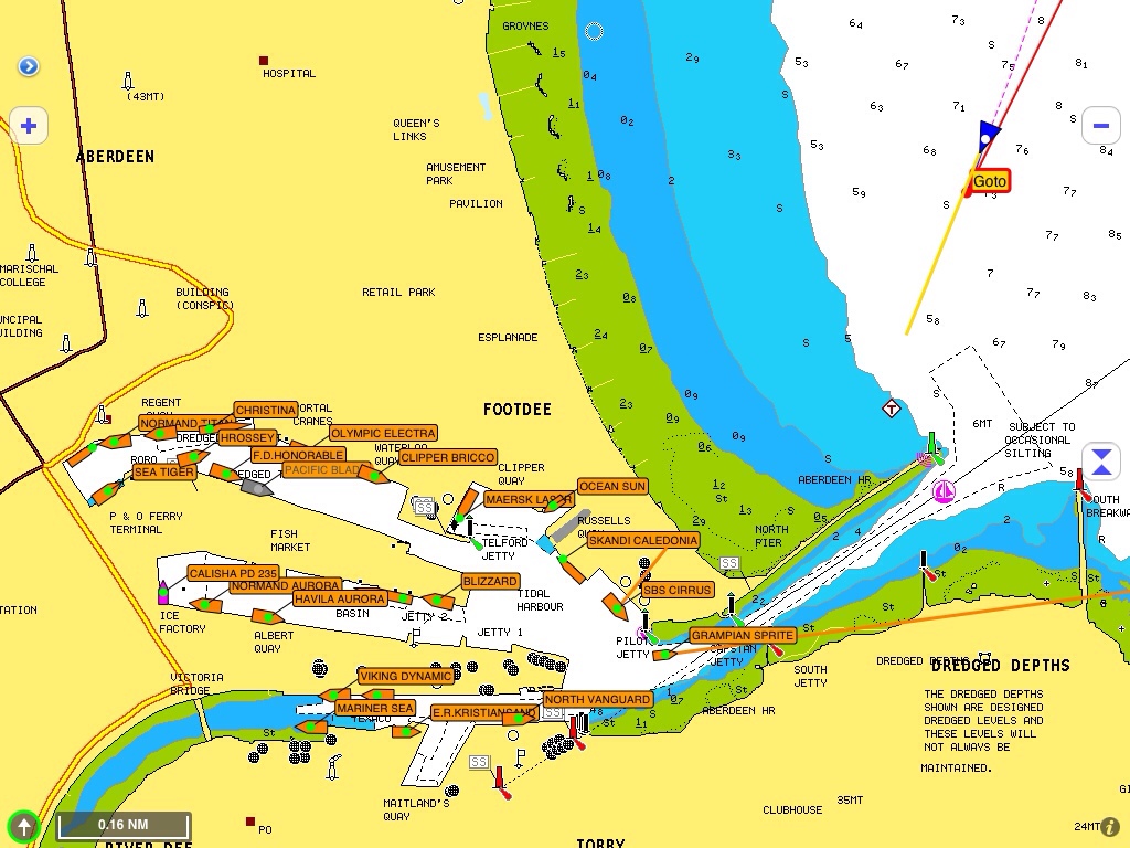
iNavX view of the port of Aberdeen showing shipping and Dawn Treader
The iPad is enclosed in a very rugged case – a Griffin Survivor – which protects the screen, is very splash proof and can withstand being dropped or thrown around. David has an iPad on board as well so we have a backup if needed.
Update: If you do use an iPad on deck be careful that it does not overheat and lock up! This happened to us in the Sound of Luing at a critical moment. We were running other forms of navigation in parallel though.
Chartplotter
We have a combined RL320C chartplotter a radar which is loaded with all of the CMAP vector charts for the UK. This system has its own, separate, GPS and is what supplies the AIS and iPad with position information.
The chartplotter and the iPad are run in parallel in case the iPad, which is being used as a mobile repeater with AIS, goes down. Which it has! The RL320C system has been on board the boat for 8 years and touch wood has been very reliable.
Paper Charts
Admiralty Leisure Portfolios
I decided to take the complete set of Admiralty Leisure portfolios which cover all of the UK except for the top of Scotland and the west coast of Ireland. The folios contain charts which are smaller and are far less expensive then buying the full sized Admiralty charts.
However using the folios has proven frustrating as the individual charts are small and you are constantly changing them. An example is crossing from the Mull of Kintye to Port Ellen when we needed 3 charts for the passage of 20nm.
Full sized Admiralty Charts
The section from above the Isle of Skye, around Cape Wrath and to the East coast of the top of Scotland needs Admiralty full size charts – which we have on board – for the detail and Imray for the overview.


3 Comments
Nigel on May 25, 2012 at 1:19 pm.
Might be able to help you with the Admiralty charts for the over the top section of your journey.
Joe Barrett on May 25, 2012 at 5:55 pm.
Nigel, I already have the Admiralty charts for the top section – thanks for the offer. The text above is not clear on that. I will correct it.
Joe
Dick and Jean on July 19, 2012 at 8:16 am.
Hi Joe. We are back from our two weeks in Austria and you and the crew are still making for home. The weather certainly has not been kind to you of late. Let’s hope that the final legs of your epic journey go smoothly and the winds are in your favour. Well done to all of you, a journey you will always remember. Speak to you soon. Jean and Dick